
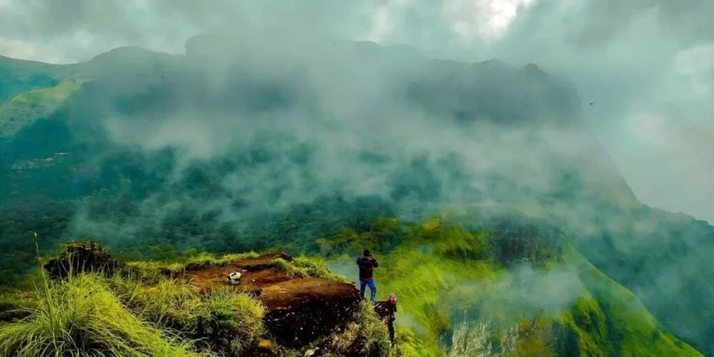
Rani Jhari Viewpoint sits amid the dramatic Western Ghats landscape around Durgadahalli in the Mudigere side of Chikmagalur district. Known for its deep valleys, steep cliff faces, rolling grasslands, and shifting mountain mist, the viewpoint attracts photographers, nature lovers, and travellers looking for a short outdoor experience away from Chikmagalur’s busier sightseeing circuits.
The destination is also closely associated with Ballalarayana Durga and the longer Bandaje Falls trek, but these experiences should not be treated as the same outing. You can visit Rani Jhari Edge Point as a shorter viewpoint trip, while the full fort and waterfall route requires considerably more preparation, time, & current forest-access checks. Karnataka Tourism confirms that the Ballalarayana Durga and Bandaje Falls route requires forest permission and recommends using an authorised guide.
Rani Jhari Viewpoint Quick Guide
Rani Jhari Viewpoint: Quick Details
Travel references place the viewpoint roughly 41 km from Mudigere and around 70 km from Chikmagalur town, although the exact journey depends on your starting point & approach road.
Whispers of the Hills: The Story Behind Rani Jhari

The appeal of Rani Jhari Chikmagalur comes from both its landscape & the story attached to its name.
Local oral tradition connects the viewpoint with a queen often identified as Rani Padmini Devi. One widely repeated version says she leaped from the cliff while trying to escape Tipu Sultan’s forces. That story appears across regional travel references, but it should be presented as local legend rather than established historical fact because reliable primary historical documentation is limited.
The name itself has become part of the character of the place. Standing above the forested valley, with mist frequently moving across the cliff, it is easy to understand why generations of local storytelling became attached to this landscape.
Rani Jhari History: What Is Known and What Is Legend?

A stronger account of Rani Jhari history should separate documented regional heritage from storytelling.
The viewpoint lies close to Ballalarayana Durga, a historic hill fort within the Western Ghats. Karnataka Tourism connects Ballalarayana Durga with the Hoysala period and identifies it as a major trekking and heritage attraction in the region.
What should not be stated as a verified fact is that Rani Jhari itself served as a formal military lookout or that the Queen Padmini story happened exactly as later retellings describe it. Those details belong to local tradition unless stronger historical documentation becomes available.
This distinction actually makes the destination more interesting: you can appreciate a real historic fort landscape while also understanding the folklore that has grown around the nearby cliff.
Where is Rani Jhari’s viewpoint?
Rani Jhari Viewpoint lies near Durgadahalli on the Mudigere side of Chikmagalur district.
It is considerably closer to the Charmadi, Mudigere, and Ballalarayana Durga landscape than to central Chikmagalur town. This matters when choosing where to stay and when planning the rest of your itinerary.
Common travel references place:
- Mudigere is roughly 41 km away
- Chikmagalur town is roughly 70 km away
- Kalasa is roughly 20 to 25 km from the wider viewpoint region
These figures are approximate & should be treated as planning guides rather than exact travel times because hill roads, rain, and approach conditions can affect the journey.
For guests staying with us at Vanaba Hillview in Maidadi, our current local attractions information places the viewpoint approximately 6 km from the property.
How to Reach Rani Jhari
The final approach is part of the experience.
Most routes lead towards the Kalabhairaveshwara Temple area near Durgadahalli before continuing along rougher local roads and walking sections.
By Road
Private vehicles can reach the broader Durgadahalli area, but the final approach includes rough, narrow, and unpaved sections.
Do not assume a normal hatchback can comfortably handle every stretch throughout the year. Heavy rain can change road conditions quickly.
Local 4×4 transport may be available depending on current conditions and arrangements.
On Foot
The final approach to Rani Jhari Edge Point is often completed on foot.
Regional travel guides describe a relatively short walk from the upper parking or trail approach, generally taking around 30 to 45 minutes depending on where the vehicle stops and your walking pace.
Treat those times as approximate because access arrangements can change.
Rani Jhari Distance From Mudigere
The commonly reported Rani Jhari distance from Mudigere is approximately 40 to 41 km.
Allow extra time for the final village and hill sections rather than judging the journey from distance alone.
Rani Jhari Distance From Chikmagalur
The commonly reported Rani Jhari distance from Chikmagalur is approximately 70 km.
If Rani Jhari, Charmadi, Bandaje, and Mudigere attractions are your priorities, staying on this side of the district can reduce unnecessary driving back towards Chikmagalur town.
Rani Jhari Trek: What to Expect
The shorter Rani Jhari trek should not be confused with the full Ballalarayana Durga & Bandaje route.
For a viewpoint-only visit, expect:
- A rough approach road
- Forest and grassland scenery
- Mud and slippery surfaces after rain
- Short climbing sections
- Sudden mist
- Exposed cliff areas
- Limited facilities near the viewpoint
Several current travel references describe the final trail as approximately 1.5 km, although the walking distance can vary according to where you park or leave the vehicle.
Is Rani Jhari Trekking Difficult?
For travellers with ordinary fitness, the Rani Jhari trekking is generally less demanding than the full Bandaje route.
The biggest concerns are often terrain and exposure rather than distance.
Take extra care if:
- It has recently rained.
- Thick mist reduces visibility.
- You are travelling with young children.
- Anyone in the group is uncomfortable around steep drops.
- Footwear does not provide sufficient grip.
Do not move towards the cliff edge simply to take photographs.
Rani Jhari vs Ballalarayana Durga Trek
The Ballalarayana Durga trek is the next step for travellers wanting a longer outing.
The fort lies on the trekking route associated with Bandaje Falls, and Karnataka Tourism describes Ballalarayana Durga as an established Western Ghats trek leading towards the waterfall region.
Choose:
Rani Jhari only if you want a shorter viewpoint visit.
Choose Rani Jhari + Ballalarayana Durga if you have additional time and suitable fitness.
Choose the full Bandaje Falls trek only when you are prepared for a considerably longer forest and grassland route.
Ballalarayana Durga and Bandaje Falls: Plan the Full Trek Separately
The Bandaje Arbi Falls experience should not be presented as a quick extension of Rani Jhari.
Karnataka Tourism describes Bandaje Falls as an approximately 200-foot waterfall in Belthangady taluk, reached through a trek involving Ballalarayana Durga. It states that forest permission is required and recommends an authorised guide.
The tourism authority describes the Ballalarayana Durga to Bandaje route as a moderate 6 to 7 km trekking experience that can take around 7 to 8 hours for the return journey, depending on route and conditions.
If You Are Planning the Full Trek
Before travelling:
- Check current Karnataka ecotourism booking requirements.
- Confirm forest permission.
- Use an authorised guide where required.
- Start early.
- Carry sufficient water & food.
- Wear proper trekking footwear.
- Prepare for sun, rain, and sudden mist.
- Check whether route restrictions have changed.
- Avoid relying on old social media instructions.
If Bandaje is central to your trip, see our homestay near Bandaje Falls.
Experiencing Rani Jhari Edge Point

The strongest reason to visit Rani Jhari Edge Point is the landscape.
The cliff opens towards layers of Western Ghats forest, grasslands, ridges, and valleys. Depending on the season, the same viewpoint can feel completely different.
On a clear morning, you may see long mountain layers stretching across the horizon.
During mistier conditions, clouds can move across the cliff within minutes, revealing and hiding the valley repeatedly.
That changing visibility is part of the appeal, but it is also why safety matters.
What Makes the Viewpoint Special?
Rani Jhari works particularly well for:
- Landscape photography
- Short nature walks
- Western Ghats scenery
- Couple and group outings
- Combining nature with Ballalarayana Durga
- Quiet mornings away from busier tourist centres
Among the lesser-known viewpoints in Chikmagalur, its combination of dramatic cliff terrain and access to the Ballalarayana Durga landscape gives it a distinct identity.
Rani Jhari Safety Tips
Rani Jhari is an exposed natural viewpoint rather than a heavily engineered tourist platform.
Recent local reporting has also highlighted unsafe behaviour involving vehicles close to the cliff area, reinforcing the need to treat the location cautiously.
Keep these points in mind:
- Stay well away from cliff edges.
- Do not drive vehicles onto exposed cliff sections.
- Avoid risky poses for photographs or reels.
- Keep children closely supervised.
- Do not trek after dark.
- Turn back if visibility becomes poor.
- Avoid slippery shortcuts.
- Follow local barriers & forest instructions.
- Carry your waste back with you.
- Do not disturb vegetation or wildlife.
A photograph is never worth stepping beyond a safe point.
View this post on Instagram
Rani Jhari Timings and Access

Searchers often look for Rani Jhari timings.
Several established regional travel guides currently list approximately 6 AM to 6 PM and no viewpoint entry fee. However, these are third-party listings rather than a permanent official operating schedule.
Access can also change because of:
- Rain
- Forest restrictions
- Road conditions
- Local administration orders
- Trek regulations
- Crowd-control measures
Check locally before travelling, particularly during monsoon, holiday periods & festival weekends.
Best Time to Visit Rani Jhari

The best time to visit Rani Jhari depends on whether you want clear views or deep monsoon greenery.
October to February: Best Overall Balance
Post-monsoon and winter generally provide a useful combination of:
- Green landscapes
- Cooler walking conditions
- Better trail comfort
- Improved chances of clear valley views
This is the easiest period for most first-time visitors.
March to May: Drier Trekking Conditions
Summer mornings can still work well for the viewpoint.
The landscape becomes drier, so visit early and carry additional water.
June to September: Dramatic but Unpredictable
The monsoon transforms the entire Western Ghats landscape.
Expect:
- Thick mist
- Intense greenery
- Rain
- Slippery mud
- Leeches in wetter vegetation
- Reduced cliff visibility
If the weather deteriorates, prioritize safety over reaching the viewpoint.
For the longer Ballalarayana Durga and Bandaje route, Karnataka Tourism recommends the post-monsoon period and notes that monsoon conditions can make the trek slushy & difficult.
Places to Visit Near Rani Jhari

The most practical places to visit near Rani Jhari are those on the Mudigere, Charmadi, and Kalasa sides of Chikmagalur district.
Ballalarayana Durga
Ballalarayana Durga is the most natural attraction to combine with Rani Jhari if you are comfortable trekking.
The ruined hill fort sits within the same broader mountain landscape and forms part of the route towards Bandaje Falls. Karnataka Tourism identifies it as a recognized Chikmagalur trekking destination.
Bandaje Falls
The full Bandaje Falls trek is better kept as a dedicated trekking day rather than added casually after sightseeing.
See us if this is the main purpose of your visit.
Charmadi Ghat
Charmadi offers sweeping Western Ghats road scenery and fits naturally into a Mudigere itinerary.
If your trip is focused on this side of the district, explore our homestay near Charmadi Ghat.
Devaramane Betta
Devaramane offers a different hill experience with open landscapes and temple surroundings.
You can explore our homestay near Devaramane Betta when planning a broader Mudigere weekend trip.
Ettina Bhuja
Ettina Bhuja is another well-known trekking destination in the Mudigere region and works better as a separate trek rather than something squeezed into the same afternoon.
See our homestay near Ettina Bhuja for local trip planning.
Kelagur Tea Estate
Tea-estate landscapes provide an easier alternative after a trekking morning. Check access rules before entering plantation areas because working estates are not automatically open public attractions.
Kalasa
Kalasa makes a useful onwards destination if your trip continues further into the Chikmagalur district.
For stays focused on that route, see our homestay near Kalasa.
Rani Jhari for Families, Couples, and Groups
Different travellers should plan the viewpoint differently.
Families
Families can enjoy Rani Jhari when children are comfortable walking, & adults maintain close supervision around exposed sections.
Avoid the visit during heavy rain or very low visibility.
Couples
Rani Jhari works well for couples looking for photography, Western Ghats scenery, & a short nature outing.
Early mornings generally provide a quieter experience.
Groups of Friends
Groups can combine Rani Jhari with Ballalarayana Durga when everyone has suitable fitness.
Do not split up on forest sections, particularly during mist or rain.
Trekkers
For trekkers researching trekking places in Chikmagalur, Rani Jhari works as the entry experience to a broader trail system rather than a full-day trek by itself.
The Ballalarayana Durga and Bandaje route provides a more substantial challenge.
A Practical Rani Jhari Day Itinerary
A focused itinerary gives you a better experience than attempting too many scattered attractions.
Early Morning: Leave for Durgadahalli
Start early to reduce heat & give yourself additional time if approach-road conditions are slow.
Morning: Rani Jhari Viewpoint
Walk to Rani Jhari Viewpoint, spend time enjoying the scenery, and return before the day becomes crowded or mist conditions change.
Late Morning: Ballalarayana Durga Option
Continue towards the fort only if:
- The group is prepared.
- Weather remains suitable
- Access is open
- You have enough daylight.
Afternoon: Easier Local Stop
After trekking, choose a lower-intensity stop such as a tea-estate drive, Charmadi scenery, or relaxed time at your stay.
Avoid beginning a full Bandaje Falls trek in the afternoon.
Planning a Mudigere Weekend Trip Around Rani Jhari
A Mudigere weekend trip works best when attractions are grouped by geography.
Day 1
Vanaba Hillview → Rani Jhari → Ballalarayana Durga or Charmadi-side sightseeing → Return to Vanaba.
Day 2
Choose one main experience:
- Bandage trek
- Devaramane
- Ettina Bhuja
- Kalasa side
- Relaxed local nature outing
This keeps your trip realistic & gives you time to enjoy the landscape instead of spending the weekend entirely inside a vehicle.
Stay Near Rani Jhari at Vanaba Hillview

Vanaba Hillview is located in Maidadi, Balige village, Mudigere Taluk, in Chikmagalur district. Our current activities page places Rani Jhari Viewpoint approximately 6 km from our property, making it one of the closest highlighted sightseeing experiences on our local activity list.
After a morning outdoors, you can return to our hill setting rather than driving all the way back towards Chikmagalur town.
View this post on Instagram
Our current property offering includes:
- Traditional Cottages
- Deluxe Cottages for multiple sharing
- Hill views
- Swimming pool
- Nature walks
- Trekking
- Campfire seating
- Indoor games
- Hot water
- Parking
Our accommodation page lists Traditional Cottages for couples and small families and Deluxe Cottages for families and groups.
Explore our accommodation or view our activities before planning your stay.
Why Base Your Trip in Mudigere?
If your priority is places to visit near Mudigere, choosing accommodation on this side of Chikmagalur can reduce repeated long drives.
From Vanaba, you can build your itinerary around Rani Jhari, Charmadi, Bandaje, Devaramane, Ettina Bhuja, waterfalls, and the Kalasa side of the district.
For a stay focused on views, see our hill view homestay in Chikmagalur.
Discover Rani Jhari Without Losing Sight of the Landscape
The real appeal of Rani Jhari Chikmagalur is not a complicated tourist setup. It is the experience of walking towards an exposed Western Ghats viewpoint where forest, grassland, cliff, and mist meet in one landscape.
Enjoy the local legend, but distinguish folklore from documented history. Visit the viewpoint as a shorter outing, and treat Ballalarayana Durga and Bandaje Arbi Falls as separate trekking commitments that require additional planning.
If you are exploring this part of Mudigere, stay close enough to leave early, return before dark, and spend the rest of the day enjoying the hills rather than retracing the road to Chikmagalur town.
At Vanaba Hillview, we offer a convenient base in Maidadi for travellers building a trip around Rani Jhari and the surrounding Western Ghats.
Frequently Asked Questions
Where is Rani Jhari Viewpoint?
Rani Jhari Viewpoint is near Durgadahalli on the Mudigere side of Chikmagalur district. It lies close to Ballalarayana Durga and the approach used for the wider Bandaje trekking region.
How far is Rani Jhari from Mudigere?
The commonly reported Rani Jhari distance from Mudigere is approximately 40 to 41 km by the wider road approach. Vanaba Hillview’s own local attraction information places Rani Jhari around 6 km from our Maidadi property.
How far is Rani Jhari from Chikmagalur?
The commonly reported Rani Jhari distance from Chikmagalur town is approximately 70 km. Travel time can vary significantly because of hill roads and final approach conditions.
Is the Rani Jhari trek difficult?
The viewpoint-only Rani Jhari trek is generally a short-to-moderate outing. The final walking distance is often reported at around 1.5 km depending on where you start. Wet weather can make the trail considerably harder.
What is the story behind Rani Jhari?
A local legend says a queen, often identified as Rani Padmini Devi, leaped from the cliff while escaping Tipu Sultan’s forces. The story is widely repeated locally but should be understood as oral tradition rather than fully documented historical fact.
What is the best time to visit Rani Jhari?
The best time to visit Rani Jhari for most visitors is post-monsoon through winter, when the hills remain green and trekking conditions are generally easier. Monsoons bring dramatic scenery but also slippery trails and reduced visibility.
Can I visit Rani Jhari and Ballalarayana Durga together?
Yes. Rani Jhari Edge Point and Ballalarayana Durga lie within the same wider trekking landscape. Continue only if current access, weather, daylight, and your group’s fitness allow.
Is Rani Jhari part of the Bandaje Falls trek?
Rani Jhari is commonly encountered around the Durgadahalli approach to the broader Ballalarayana Durga trek and the Bandaje Falls trek. The full Bandaje route is significantly longer and requires current forest-permission checks.
Do I need permission to visit Rani Jhari?
A short viewpoint visit and the full forest trek should not be treated identically. Karnataka Tourism specifically states that the Ballalarayana Durga and Bandaje Falls trek requires forest permission. Confirm current local requirements for your planned route before travelling.
Are there fixed Rani Jhari timings?
Third-party travel references commonly list Rani Jhari timings around 6 AM to 6 PM, but access conditions can change. Check locally before departure rather than treating those hours as permanently guaranteed.
Is Rani Jhari suitable for children?
Older children who are comfortable walking may enjoy the viewpoint, but the cliff is exposed and requires close adult supervision. Avoid the outing during heavy rain, poor visibility, or unsafe trail conditions.


